Cycling in Waterford gives you flexibility in your commute and freedom to explore the city and county. Cycling is one of the most sustainable forms of travel and a family friendly activity. As a transport option cycling has one of the lowest impacts on the planet and the environment, impacting positively on air and noise pollution.
Cycling in Waterford
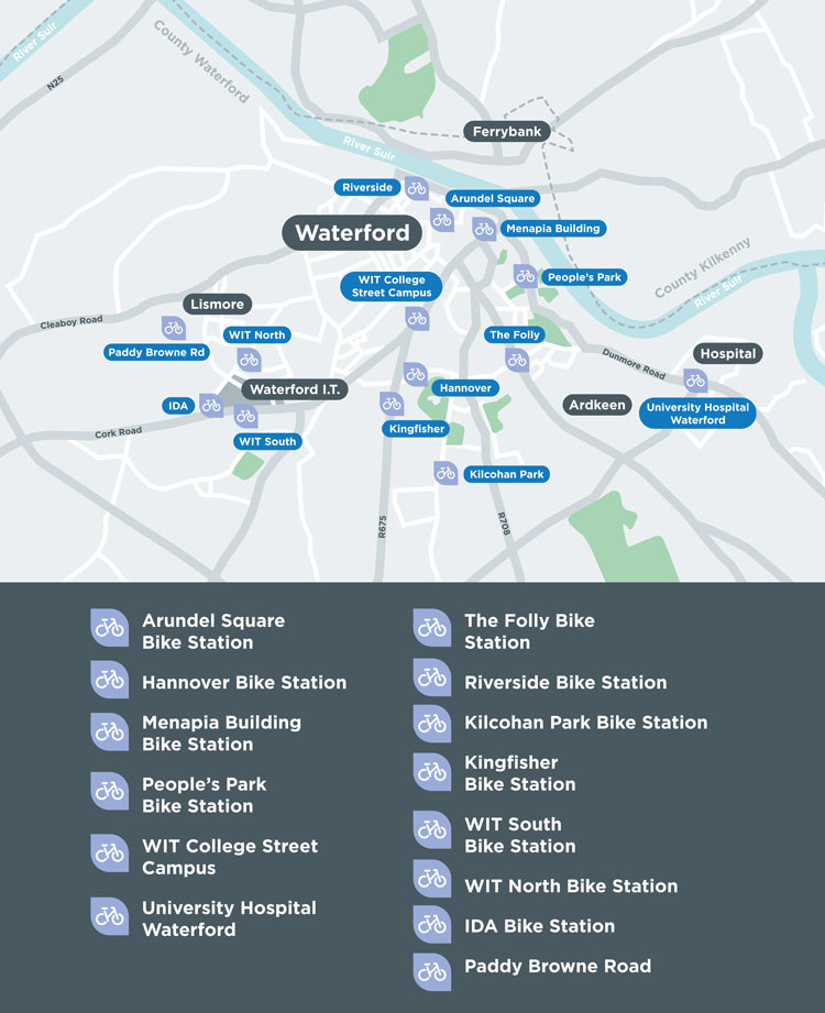
TFI Shared Bike Scheme
TFI Bikes stations are located in key areas around the city, including the city centre, SETU and University Hospital Waterford. With 14 stations and 220 bikes, TFI Bikes are an ideal way to explore Ireland’s oldest city. TFI Bikes are also great for leisure rides and for tourists visiting the city.
Download the TFI Bikes App to manage your account and for information on station locations, bike and stand availability and route planning.
The TFI bikes app is available through the website bikeshare.ie.

Bike parking
Bike parking stands can be installed on publicly accessible land where there is enough space so that parked bikes do not interfere with footpaths, cycle tracks, roadways or access to private premises.
Approximately 400 bike parking spaces have been installed in Waterford by the Active Travel programme since 2021 (data from September 2023). Please forward any suggested locations for additional bike parking to ActiveTravel@waterfordcouncil.ie
Park & Cycle
The Waterford Greenway SETU West Campus Car Park at Carriganore (Google Maps) is designated as a ‘Park & Cycle’ carpark. The journey to Waterford City Centre from the SETU West Campus Car Park is approximately 7km (a 30-minute cycle) via the greenway to Waterford City Centre. Car parking is free at this location and offers a sustainable and healthy option for commuters to travel into the City Centre.
Other ‘Park & Cycle’ locations will be identified in the future as the cycle network is extended throughout the Waterford Metropolitan Area and County.
Waterford Bike Week
Bike Week is a celebration and promotion of the benefits of cycling. Each year, Waterford Council runs a series of free cycling activities, events and workshops for Bike Week, which are aimed at all ages and levels from new to advanced cyclist.
Bike week is funded by the Department of Transport and cycling activities are planned by Waterford City and County Council and Waterford Sports Partnership.

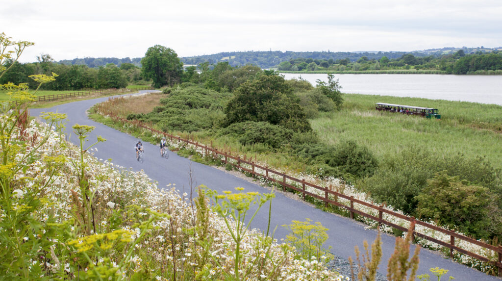
Waterford Greenway
The Waterford Greenway, known locally as the Déise Greenway, is a 46km long walking and cycling route between Waterford City Centre and Dungarvan. The route follows the former railway line from Waterford to Mallow, and it forms part of EuroVelo 1 route.
The Waterford Greenway runs links Waterford City, Mount Congreve, Kilmeaden, Kilmacthomas, and Dungarvan, featuring 11 bridges, three viaducts, a 400-metre long tunnel, and passes along part of the Copper Coast.
The Bilberry to City Centre Waterford Greenway Link was opened in June 2023 and links the Greenway into the heart of Waterford City Centre. This link will improve safety for greenway users and provides direct access from the greenway to shops, restaurants and tourist attractions in the City Centre.
Cycle Network Plans
The Waterford Metropolitan Area Transport Strategy (External Link: WMATS) includes a number of measures for implementing the ‘Cycle Network Plan for Waterford City and Environs’ report (Link to 2014 report) in conjunction with supplementary ‘soft’ initiatives for reinstating a strong cycling culture in Waterford City and Environs.
The National Development Plan commits to the delivery of cycle networks for all of Ireland’s cities. Translating this at a regional level, the draft Cycle Network Plan for Waterford City and Environs has formed the basis of Waterford Metropolitan Area cycle network. Additional proposals will align with BusConnects schemes, the Waterford Greenway, and key trip attractors such as ‘Park & Cycle’ and ‘Park & Ride’ facilities.
WMATS identifies that high-quality infrastructure and supporting measures are required to cultivate a cycling culture in the Waterford Metropolitan Area, and to give all individuals the choice to cycle, including:
- Identification of Primary, Secondary, Inter-Urban, Feeder and Greenway Routes;
- Facilities designed to National Cycle Manual standards including cycle parking;
- Full or light segregation from other modes to ensure safety and comfort for all road users;
- Local traffic calming, lower speed limits and junction treatments, particularly at complex junctions in an urban context; and
- Careful provision within pedestrian environments in central areas.
In addition to dedicated cycle route types throughout the Waterford Metropolitan Area, provision of filtered permeability measures will be pursued in existing and new residential developments. Filtered permeability or connectivity links aim to improve linkages at the local level for walking and cycling to school, work or the shops. If you have a know of a connectivity link that could be implemented or improved, email ActiveTravel@waterfordcouncil.ie with your suggestion.